Our morning walk
is intended as exercise as well as pleasure. I confess the mere act of walking
is a pleasure. I don’t need much else, but this is a joint venture. Bryony
occasionally reminds me as I lurch in front of her. A little conversation
between us is ‘de rigeur’.
The sidewalk out of Harleston down to the Needham
roundabout, however is definitely single file. (Please excuse the Americanism
but it is a much better description of a path beside a road, than the more conventional
footpath.) The traffic coming up from the roundabout tends to put pay to any
but traffic related conversation.
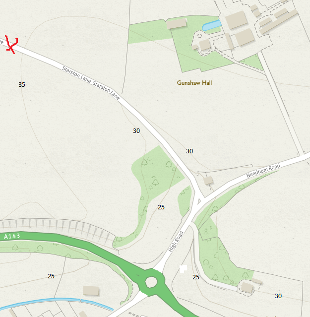
By the time we got to the turn off to Starston Lane, and I
had set the lap time on my newly acquired all singing, all dancing sports stop
watch, Bryony was mildly irritated. She showed this by walking behind me rather
slowly. This is a sure sign. Bryony’s longer legs normally have me working hard
to keep up with her on this gentle slope. This is a shaded shallow gully and we
have to keep our ears alert for vehicles coming behind us. The gully opens out
after a couple of hundred yards.
Inevitably, we keep on listening for vehicles; the
articulated chicken shit trucks are very big indeed. But once out in the open
we hear a lot more. My directional hearing is pretty naff and I don’t think
Bryony’s is much better. So we can’t work out whether it’s from the road behind
us or over the valley until it is fairly close. I determined to look at the
layout in three dimensions using the Ordnance Survey maps
contour lines.
 |
| Gully at the start of Starston Lane |
The gully starts at the triangular junction between High Road, Needham
Road and Starston Road on the map above.
By the time we reach the squiggly red cross, the gully
has opened out and the sounds of vehicles are coming over from the Harleston
bypass (marked A143 east of the roundabout). It is difficult to be sure of the
exact direction from which the sound is coming. You will notice though, that
there is a small copse of woodland and a dwelling surrounded by trees I suspect
that this protects us from vehicle noise coming the bypass to the west of the
Needham roundabout.
Once round the bend, the country on either side of Starston
Lane opens up even further. This year the field to the west are being used by
Wharton’s as rose nurseries while to the east the fields are planted to cereals
(not rape this year thank goodness). We are both sure that we can hear traffic
coming from both directions.
The map below, at a slightly larger scale, shows clear lines
of hearing both from the east and the west along the A143. This is the case
only once we’ve walked through the long right angled bend in Starston Lane and
are heading along the straight towards Cranes Watering Farm.
 |
| Towards Cranes Watering Farm. Can hear traffic from both east and west. |
Contour Lines
It is difficult to see contour lines from images of OS maps.
This problem is exacerbated by the fact that contours are considered less
important than other information on the map. Accordingly, if there is a road or
a boundary of any sort that always takes precedence. It is not always easy to
match up broken contours.
 |
| Contour lines just about visible |
Also the online version of the OS map does not appear
to give any heights for its contours. The image above shows a series of
contours, where I have marked in the heights values, taken from the paper
version of the same area.
 |
| Paper version showing contour heights |
I had to follow these contours through to Starston Lane, to
mark the map images above. I still can't be sure that they are correct.
No comments:
Post a Comment